
Android Tide and Current Apps : "Tide Now"

- Written and Published by Lawrence Freytag
- Usage Instructions
- Features
- Icons, Menu and Gestures
- Tide Station Listing by State
- Privacy and Data Safety
Update October 10th, 2023 :Thinning of the Herd
Google Play have mandated yearly updates for each app.
I cannot maintain
my whole collection of regional tide applications.
I have unpublished all but 10 apps, My Android tide apps are in sustaining mode only.
My currently published and updated for Android 13 apps are:
Nationwide Tide Coverage : Tide Now USA West, Tide Now USA Northeast, Tide Now USA Southeast, Tide Now Chesapeake
State Apps with extended features : Tide Now WA, Tide Now OR, Tide Now CA, Tide Now AK, Tide Now HI
Regional Special App : Tide Now Puget Sound Tides and Currents
Please contact me if you have any concerns about the unpublished apps. I will work with you on it.
Summer/Fall 2022. I am updating selected state tide apps. This includes support for Android 12, updating/checking all stations, and adding missing stations where feasible.
The main feature add is a Show Chart button, and inclusion of Raster Navigation Chart segments to show where each station is located. After you have selected a station,
tapping the show chart icon causes the station location to be displayed on a navigation chart.
An overview chart is shown, you can zoom and pan to see in full resolution.
So far, Hawaii, Oregon, California, and Washington apps have been updated.
May 2022. New App: Global Sun and Moon, it gives you the sun and moon data as shown in tide apps but it can be used in any location world wide. It also shows
the various twilight stages to show light available when the sun is below the horizon.
It is called Sky Light Now, see http://sky-light-now.lfreytag.com.
In the last year, I've been building complete tide and current apps for given areas.
Each includes a chart, which is extra important for current stations, given
that they are out there somewhere in the water. Charts can be panned and zoomed
to see the whole area or a close up.
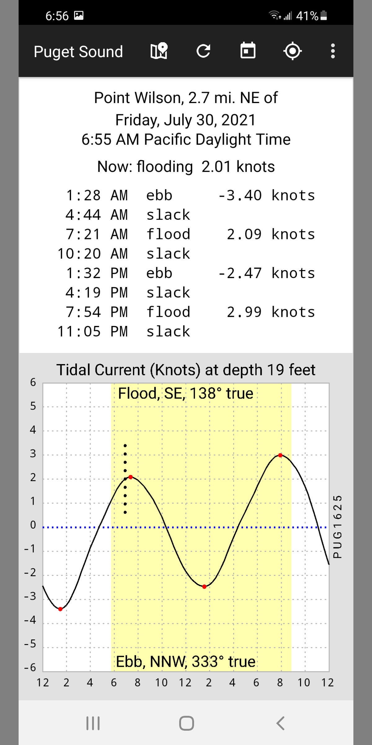
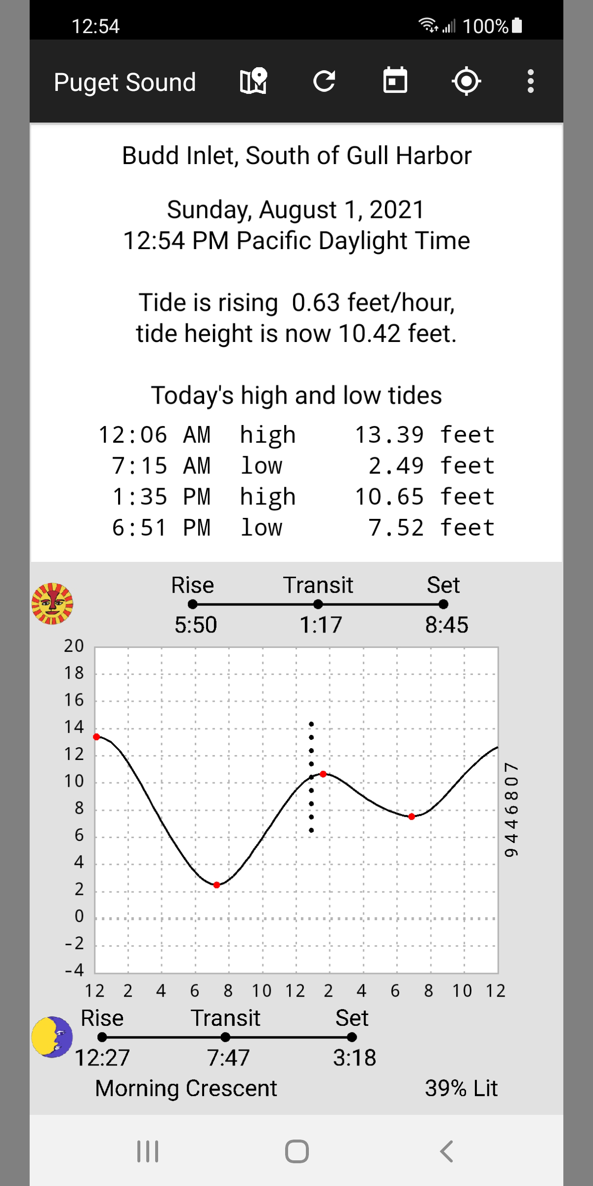
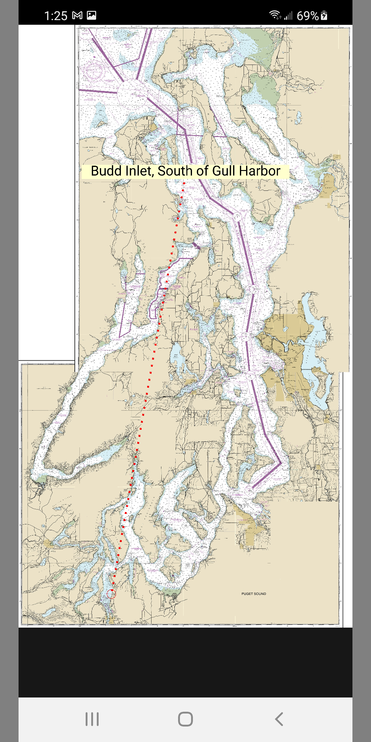
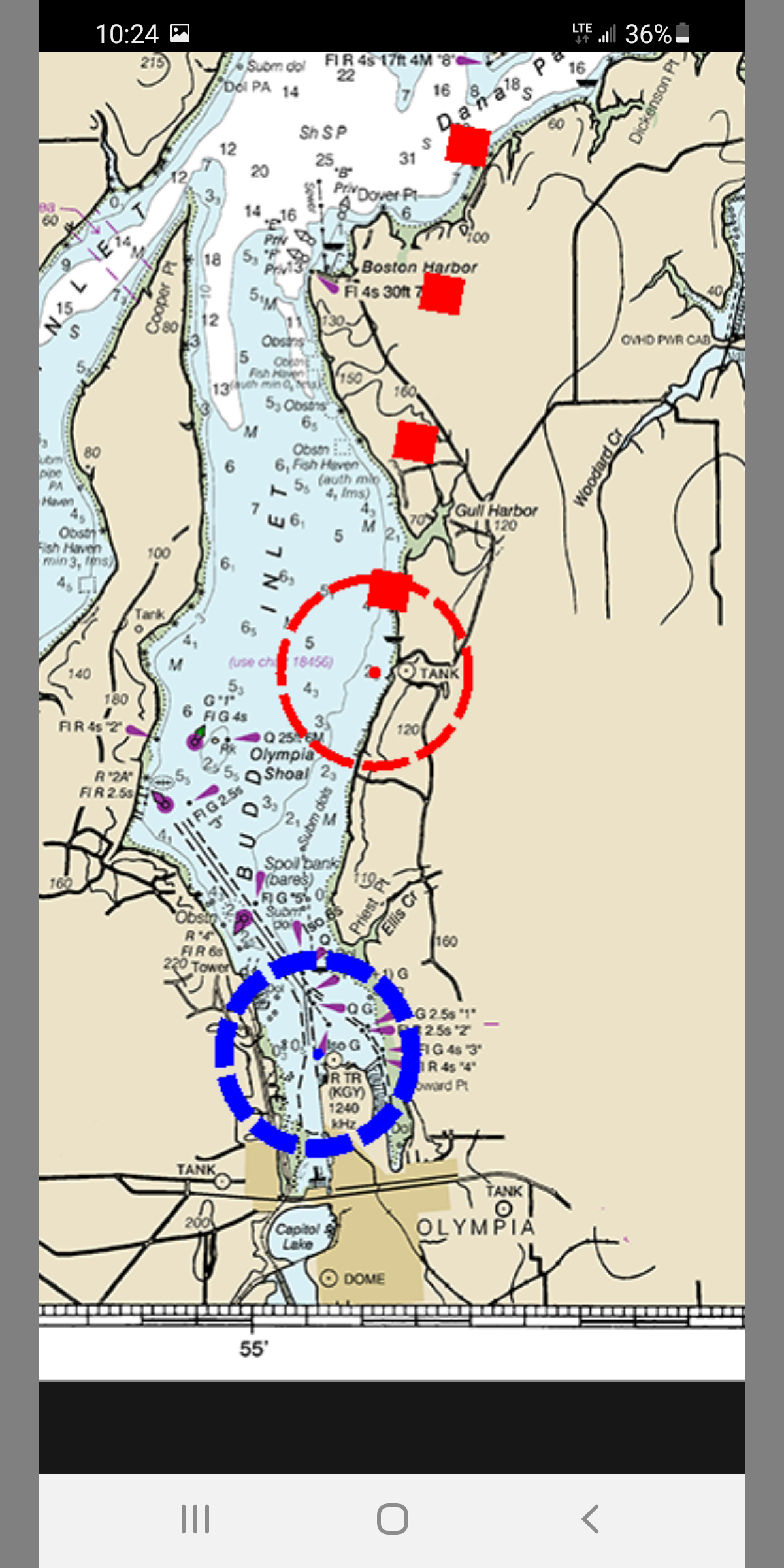
August 1st, 2021: Tide Now - Puget Sound Tides and Currents is published.
83 Tide Stations, 59 Current stations, with built in chart showing the location of
each station.
Also an initial version of GPS location display (blue dot).
https://play.google.com/store/apps/details?id=lfreytag.TideNowPS
June 20th, 2021: Tide Now - San Juan Islands Tides and Currents is published.
https://play.google.com/store/apps/details?id=lfreytag.TideNowSJI
55 current stations, 41 tide stations, built in chart.
July 30, 2020 Tide Now - San Francisco Bay Tides and Currents
I have included all the tide and current stations in the approach, the Golden Gate Strait, and
San Francisco Bay
in this app. There is a new Show Station on Chart command that shows you where your selected
station is located. The graph is enlarged and the current display stations show the directions of the ebb and flood
currents. see
June 19, 2020 I now have the United States covered for both Android and IOS.
June 18, 2020: Tide Now USA Southeast for Android.
March 23, 2020: Tide Now USA Southeast for IOS.
USA Southeast covers North Carolina, South Carolina, Georgia, Florida, Alabama, Mississippi,
Louisiana, and
Texas.
See http://tide-now-ios.lfreytag.com for information about my iPhone apps
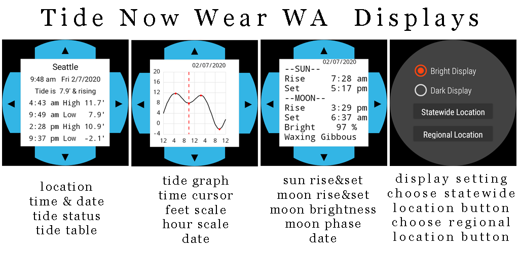
February 2020: New Wear OS apps Tide Now Wear WA, Tide Now Wear CA. These are stand alone wear apps
that run on a Wear OS Watch (I am using a gen5 fossil)
. You use the top and bottom buttons to cycle thru
the tide table, tide graph, and sun/moon displays. You use the left and right buttons to move through dates.
You go up from the tide table display to get to the settings screen. There you can change the
station or choose bright or dark display. When you change the station, you can do it one of two ways. Statewide
Location prompts you for both the region, then the station, it is a 2 step process. Regional Location only
prompts you for a station (within the currently selected region) so it is quicker to use.
***All my Android apps and play store links for them. For my IOS apps look here. ***
LARGE REGION APPs The four of them cover the United States.
| Tide Now USA West | Washington, Oregon, California, Hawaii, Alaska | USA West |
| Tide Now USA Northeast | Maine, New Hampshire, Massachusetts, Rhode Island, Connecticut, New York, New Jersey | USA Northeast |
| Tide Now Chesapeake Bay | Maryland, Virginia, Delaware, Washington D.C. | Chesapeake |
| Tide Now USA Southeast | North Carolina, South Carolina, Georgia, Florida, Alabama, Mississippi, Louisiana, and Texas | USA Southeast |
SINGLE STATE
| Tide Now Washington | WA |
| Tide Now Oregon | OR |
| Tide Now California | CA |
| Tide Now Hawaii | HI |
| Tide Now Alaska | AK |
| Tide Now Maine | ME |
| Tide Now Georgia | GA |
| Tide Now Louisiana | LA |
| Tide Now Texas | TX |
AREA / SPECIAL
| Tide Now CR (Columbia River) | CR |
| Tide Now Carolinas | Carolinas |
| Tide Now Tampa | Tampa |
| Tide Now Wear CA | Wear CA |
| Tide Now Wear WA | Wear WA |
August 2019: My original tide app, Tide Now WA for Android has been updated with 13 Tidal Current Stations,
several requests were received for current stations.
PCT1291 Grays Harbor Entrance, Washington
PUG1642 Strait of Juan de Fuca Entrance (102ft)
PUG1641 Pillar Point, 6 mi.NNE of (41ft)
PUG1639 Angeles Pt., 2 mi. NNE of (12ft)
PUG1635 New Dungeness Light, 2.8 mi. NNW of (52ft)
PUG1623 Point Wilson, 0.6 mi. NE of (17ft)
PUG1610 Foulweather Bluff, 1.9 mi. NE of (20ft)
PUG1515 West Point, West of (16ft)
PUG1527 The Narrows, 0.3 miles North of Bridge (23ft)
PUG1539 Dana Passage (16ft)
PUG1701 Deception Pass (Narrows) (18ft)
PUG1703 San Juan Channel, south entrance (75ft)
PUG1718 Haro Strait, 1.2 nm west of Kellett Bluff (66ft)
An offline tide, sun, and moon app
Note for multi state apps. These work just like the existing apps, except you can jump to different states by swiping up
and choosing the state. The apps display times in the time zone of the state you are looking at,
for less confusion about time zones. These apps are recoded with more
features including "mark height", "auto day-night display", and "grid control".
When you first install one of the multi state apps, you will be prompted to select a state on the first run.
After you do that, navigation to the desired stations will be as normal (shown below).
At any time, you can swipe up and select a different state.
Favorites will remember the state as well as the region and station.
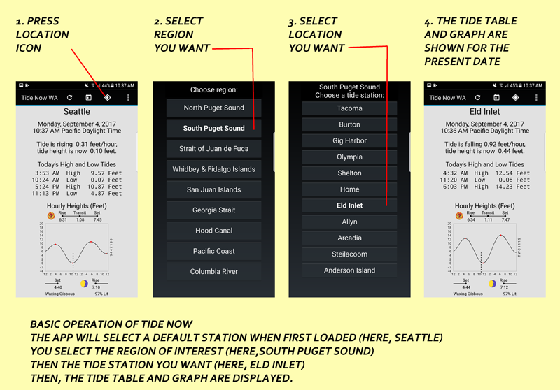
BASIC USE DIAGRAM: AFTER LOADING THE APP, CHOOSE A STATION AS FOLLOWS.
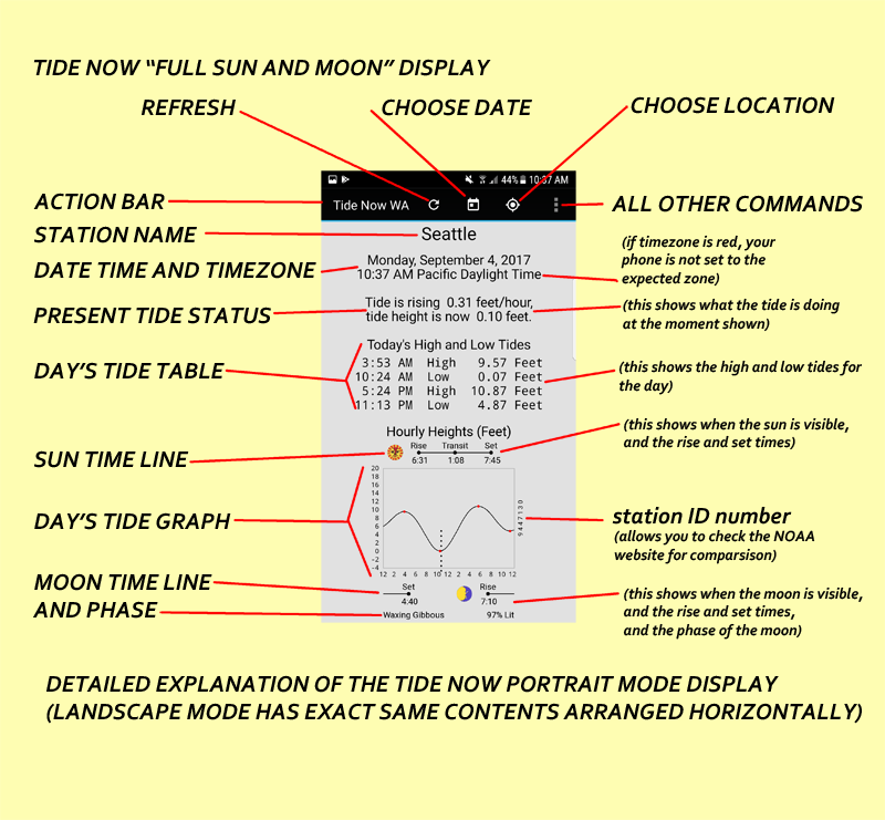
DETAIL DIAGRAM OF TIDE NOW DISPLAY:
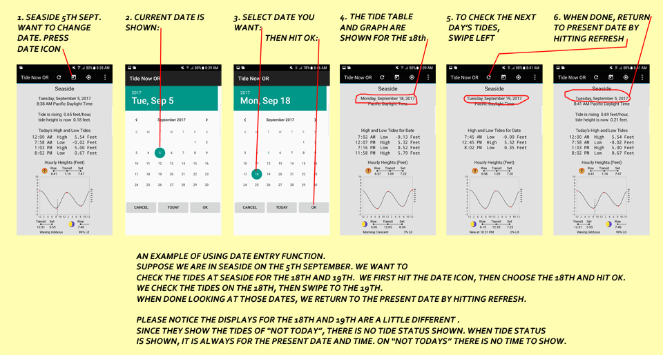
EXAMPLE USING DATE ENTRY DIALOG:
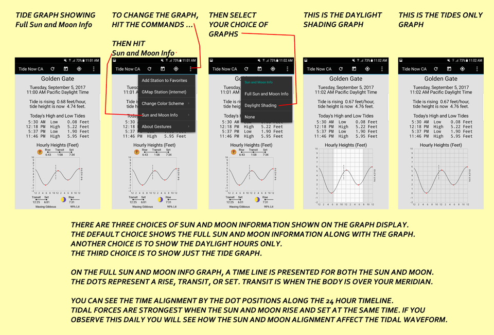
CHANGING THE GRAPH DISPLAY FOR VARIOUS SUN AND MOON INFORMATION
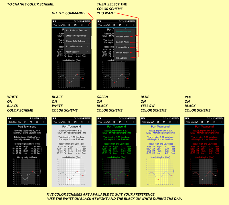
CHANGING THE COLOR SCHEME TO SUIT YOUR NEEDS:
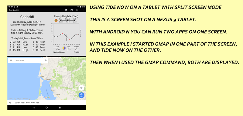
USING GOOGLE MAP COMMAND WITH A SPLIT SCREEN DISPLAY
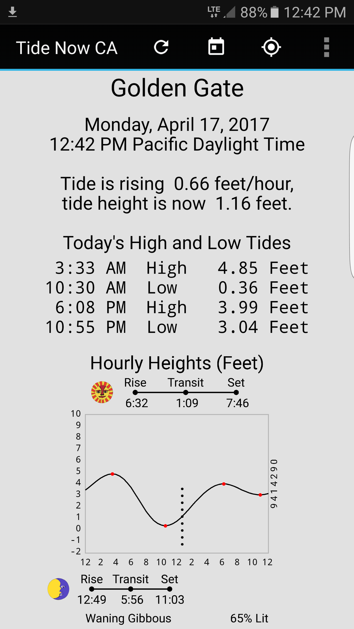
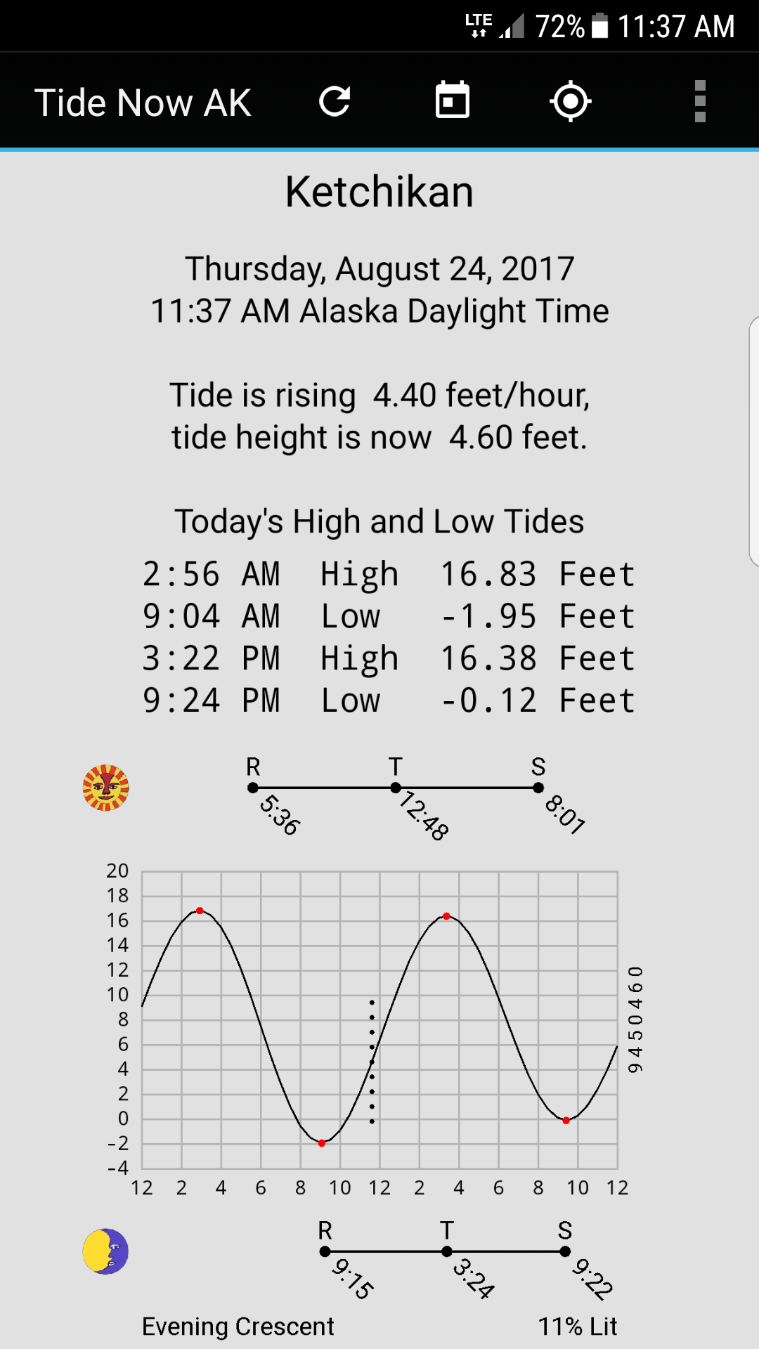
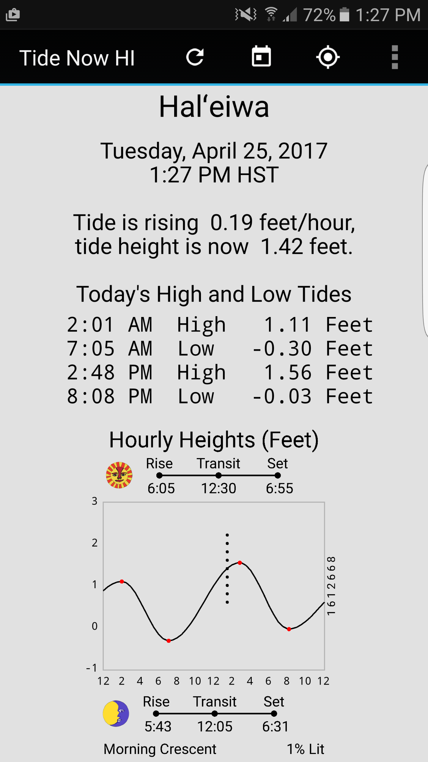
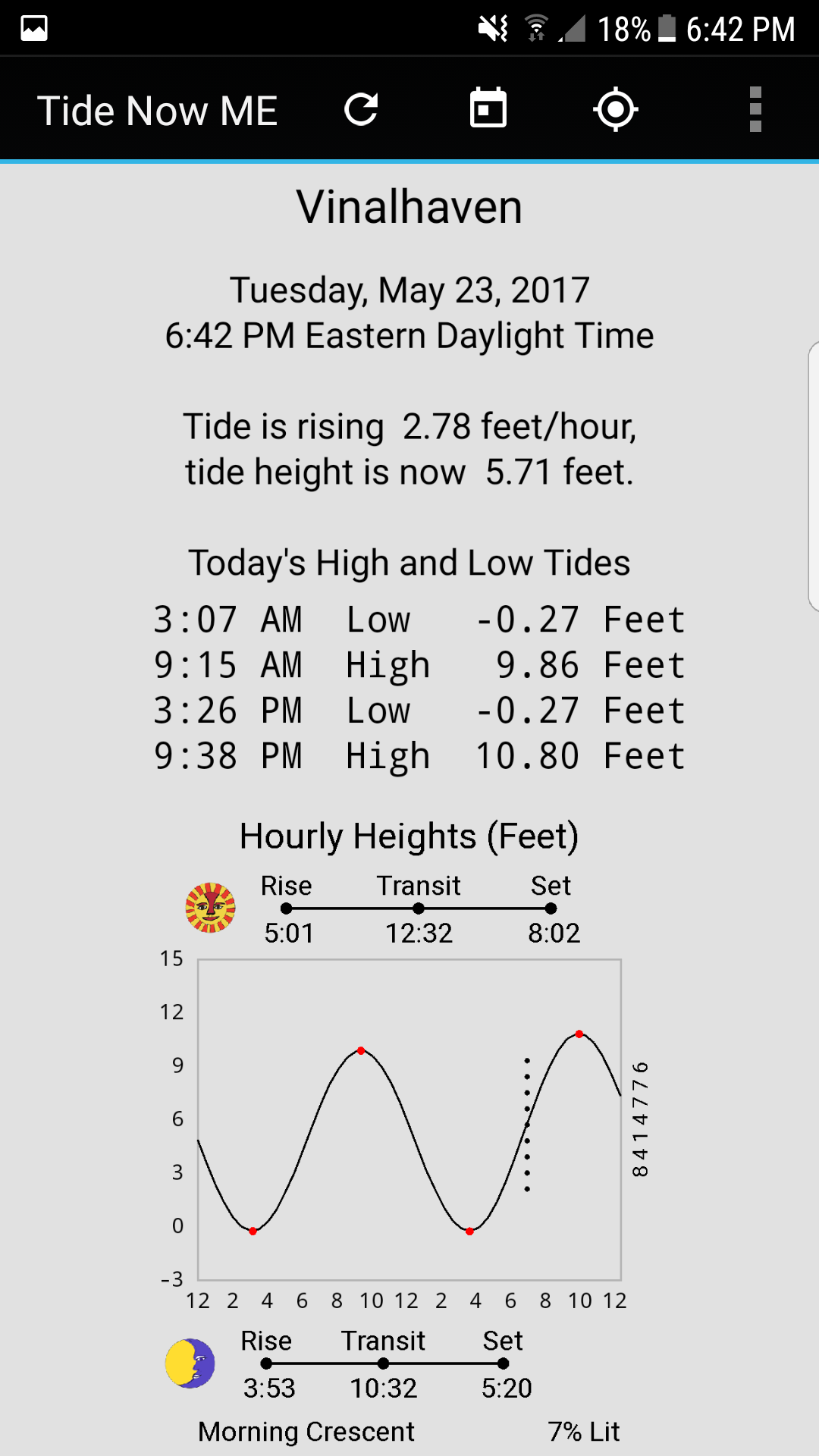
Here are the displays of the various state tide apps:
 " "
" "
 " "
" "
 " "
" "
 " "
" "
 " "
" "
 " "
" "
 " "
" "
Features of Tide Now App
| Self Contained | This app does not use the internet to get its results. It performs its function purely by calculation. It will work on a phone or a tablet in or out of range of communications. |
| Quick Simple and Clean | Predictions are quick and the app is simple to use and understand. Gestures are supported for looking at the next and prior day tides. There are no ads and app cannot access phone features. The app is small, under 300 KB, varies by state. |
| Simple User Options | There are controls for the user, provided on the action bar and settings menu, to set it up as desired. |
| Phone or Tablet | The app works on any Android device at level 4 or above, many phones and tablets are supported. Depending on the nature of your android device, the landscape or portrait mode display may present a more useful size. |
| Accurate Predictions | This app was written using well-known tidal prediction algorithms and publicly available location data. It can be expected to match very closely to federally-published tide tables. It uses the "Harmonic Prediction of Tides" methodology in long use for tide elevation predictions. |
| Designed for On The Spot Use | The tidal status presentation gives an immediate snapshot of the tide situation, more useful than just a standard list of highs and lows. The display can be refreshed at any time to update this status. This app is designed for use while actively out and about along the waterfront. It uses large text and the white on black text choice is easily read on the bright sun. |
200 Year Calendar |
In addition to today's tides, a date picker is available to choose any date from 1901 to 2100. The app does not have to be refreshed on the new year. |
| Next Day, Prior Day Swipes | Gestures are supported to go to "next day" and "past day" to step day by day through a range of dates. These operate like turning the page of a book. You can quickly swipe through a range of dates to look for good clam digging days. |
| Favorites | The selected station can be added to a set of eight favorites. These can be accessed by a down-swipe. |
| Adjustable Colors | There are five color schemes, good for situations ranging from bright sun to night use. Try each one out depending in which conditions you use the app you can find one that works best. |
| Graph Choices | Three graph choices are available. The original shows the tides. The daylight hours choice indicates which times are illuminated by the sun. The Full Sun and Moon shows rise, transit, and set times for the sun and the moon, along with the phase of the moon. |
| Numerous Tide Stations | Each state app is broken down to regions and stations depending on the state. The design is oriented to names on the ground, suitable for non expert users. |
Command Icons, Menu and Gestures
The LOCATION ICON on the action bar allows you to specify which location you want the tides for. When pressed it will give a choice of regions, when one is selected then you will get a choice of stations within that region.
The DATE ICON on the action bar allows you to enter a date, if you are considering days other than today such as planning a clamming trip. Normally you can leave this alone otherwise.
The REFRESH ICON brings the display to the present date and time. If you have changed the date, this will restore the date to the present date. If the app has been sitting idle for some time, you might want to press the refresh to update the current tide status and time mark on the graph. These change throughout the day.
Menu Item ADD STATION TO FAVORITES. This command allows you to choose one of eight shortcut locations for the presently selected station.
Menu Item GMAP STATION (Internet). This command passes the presently selected station's geographic coordinates to Google Maps App (if installed). A map is shown which is centered on the stations defined location. Some apps include a choice of scale (width of map in miles) .
Menu Item SUN AND MOON INFO. You can choose the plain graph (Tides only), the daylight hours graph, or the full Tides/Sun/Moon graph.
Menu Item CHANGE COLOR SCHEME. You can select a color scheme that suites you and the time of day. (See below).
Menu Item ABOUT GESTURES. This command lists the three gestures available; if you select one it will perform that gesture as an example.
SWIPE LEFT (NEXT DAY) Gesture. Shows tomorrows ( or next day's tide ).
SWIPE RIGHT (PRIOR DAY) Gesture. Shows yesterday's (or previous day's tide).
SWIPE DOWN FAVORITES MENU Gesture. Shows the eight defined favorites or shortcuts. Touching one of them will change the app so it displays that station.
STATE by STATE TIDE STATIONS
WASHINGTON STATE
North Puget Sound Region
Seattle, Des Moines, Bremerton, Eagle Harbor, Everett, Edmonds, Kingston, Port Madison, Poulsbo, Point Vashon, Tulalip
South Puget Sound Region
Strait of Juan de Fuca RegionTacoma, Burton, Gig Harbor, Olympia, Shelton, Home, Eld Inlet, Allyn, Arcadia, Steilacoom, Anderson Island
Port Townsend, Dungeness Bay, Sequim, Gardiner Discovery Bay, Port Angeles, Crescent Bay, Sekiu, Neah Bay, Twin Rivers, Tatoosh Island
Whidbey and Fidalgo Islands Region
Langley, Bush Point, Admiralty Head, Keystone Harbor, Freeland, Coupeville, Oak Harbor, La Connor, Cornet Bay, Anacortes, Bowman Bay
San Juans Region
Upright Head, Richardson, Telegraph Bay, Orcas, Rosario, Friday Harbor, Roche Harbor, Hanbury Point, Kanaka Bay, Turn Point, Waldron Island, Sucia Island
Georgia Strait Region
Point Roberts, Blaine, Cherry Point, Ferndale, Sandy Point Lummi Bay, Point Migley, Village Point, Goosebury Point, Bellingham Bay, Chuckanut Bay
Hood Canal Region
Port Ludlow, Port Gamble , Bangor, Whitney Point Dabob Bay, Pleasant Harbor, Seabeck Bay, Triton Head, Ayock Point, Union tides, Lynch Cove
Pacific Coast Region
Foulweather Bluff, Makah Bay, La Push, Point Grenville, Ocean Shores, Aberdeen Hoquiam, Westport, Bay City Grays Harbor, Cosmopolis, Chehalis River, Toke Point Willipa Bay, Long Beach Nahcotta
Columbia River Region
North Jetty, Jetty A Fort Canby, Cape Disappointment, Ilwaco, Chinook, Hungry Harbor, Harrington Point, Astoria OR, Skamokawa, Longview, Vancouver
OREGON
Columbia River Mouth
North Jetty, Jetty A, Cape Disappointment, Ilwaco, Chinook, Hammond, Warrenton, Astoria Port Docks, Astoria Youngs Bay, Cathcart Landing, Hungry Harbor, Astoria Tongue Point
Columbia River Upriver
Settlers Point, Harrington Point, Knappa, Skamokawa, Wauna, Longv iew, Saint Helens, Rocky Point, Vancouver, Portland
Pacific Coast North
Seaside, Nehalem, Brighton, Barview Tillamook Bay, Garibaldi, Bay City, Dick Point, Netarts, Nestucca Bay, Cascade Head, Lincoln City Taft, Depoe Bay
Pacific Coast Central
Yaquina Bar, Newport Yaquina USCG, South Beach, Weiser Point, Winant, Toledo, Waldport, Drift Creek Alsea River, Suislaw River, Florence USCG Pier, Florence
Pacific Coast South
Half Moon Bay, Gardiner, Reedsport, Charleston, Coos Bay Sitka Dock, Empire, Coos Bay COE Dock, Bandon, Port Orford, Wedderburn, Gold Beach, Brookings
CALIFORNIA
Region Del Norte-Humboldt
Pyramid Point, Mad River Slough, Arcata Wharf, Eureka Slough, Crescent City, Trinidad Harbor, Eureka, Samoa, Bucksport, North Spit, Fields Landing, Shelter Cove
Region Mendocino-Sonoma
Westport, Fort Bragg Landing, Noyo Harbor, Mendocino Bay, Point Arena, Arena Cove, Green Cove Sea Ranch, Fort Ross, Bodega Harbor, Petaluma Marina, Petaluma River, Hog Island
Region Marin
Tomales Bay Entrance, Blake Landing, Marshall, Reynolds, Inverness, Point Reyes, Bolinas, Point Bonita, Sausalito, Point Chauncey, Point San Quentin, Point San Pedro
Region Solano
Vallejo, Mare Island, Benicia, Pierce Harbor, Suisun City, Bradmoor Island, Collinsville, Rio Vista, Snug Harbor
Region Sacramento-San Joaqin
Sacramento, Clarksburg, Blackslough Landing, Stockton, Terminous, Wards Island, New Hope Bridge, Orwood Old River, Bishop Cut, Irish Landing
Region Contra Costa
Point Isabel, Richmond Inner, Richmond, Point Orient, Pinole Point, Suisun Point, Crockett, Port Chicago, Pittsburg, Mallard Island, Antioch, Bethel Island
Region Alameda
Berkeley, Oakland Pier 40, Alameda, Oakland Inner Harbor, Park Street Bridge, San Leandro Marina, San Leandro Channel, Alameda Creek, Coyote Hills Slough, Dumbarton Bridge, Newark Slough, Coyote Creek
Region San Francisco
Golden Gate, Alcatraz Island, North Point Pier 41, Yerba Buena Island, Pier 22 Rincon Point, Potrero Point, Hunters Point, Ocean Beach Outer, San Francisco Bar, Farallon Island
Region San Mateo
South San Francisco, Oyster Point Marina, Point San Bruno, Seaplane Harbor, Coyote Point Marina, San Mateo Bridge, Smith Slough, Redwood City, Palo Alto Yacht Harbor, Pillar Point Harbor, Ano Nuevo Island
Region Santa Cruz-Monterey
Santa Cruz, Elkhorn Yacht Club, Moss Landing Harbor, Elkhorn, Elkhorn Slough RR, Moss Landing, Monterey, Carmel Cove, Mansfield Cone
Region SL Obispo-Santa Barbara
San Simeon, Port San Luis, Point Arguello, Gaviota State Park, Santa Barbara, San Miguel Island, Santa Rosa Island, Santa Cruz Island, Santa Barbara Island
Region Ventura
Mussell Shoals, Ventura, Port Hueneme, Mugo Lagoon Pier, San Nicolas Island
Region Los Angeles
Santa Monica, El Segundo, King Harbor, Cabrillo Beach, Los Angeles, Mormon Island, Long Beach, Long Beach Inner, Catalina Harbor, Avalon, San Clemente Island
Region Orange-San Diego
Los Patos, Santa Ana River, Balboa Pier, Newport Beach, San Clemente, La Jolla, Crown Point, Quivira Basin, Point Loma, San Diego, National City, Imperial Beach
ALASKA
Ketchikan-Gateway Region
Ketchikan, Metlakatla Port Chester, Custom House Mary Island, Magnetic Point Union Bay, Burrough Bay Behm Canal, Bradfield Canal, Mop Point Thorne Arm, Natak Harbor, Rudyerd Bay, Prince Rupert BC
Prince of Wales Island Region
Craig, Lindeman Cove, Nossuk Bay, Trocadero Bay, El Capitan Passage, Port Alice Heceta Island, Security Cove Dall Island, Port Protection
Wrangell-Petersburg Region
Wrangell, Petersburg, Kake Harbor Keku Strait, Leconte Bay, Reef Point Stikine Strait, Saginaw Bay Kuiu Island, Monte Carlo Island, Beecher Pass
Baranof-Chichagof Islands Region
Sitka, Hoonah Port Fredrick, Elfin Cove, False Bay Chatham Strait, Port Alexander, Baranof Warm Spring Bay, Pelican Harbor, Sergius Narrows
Juneau Region
Juneau, Angoon Killisnoo, Gustavus Bartlett Cove, Funter Bay, Hawk Inlet, Auke Bay, Taku Point Taku Inlet, Port Snettisham Crib Point
Skagway-Haines Region
Skagway, Haines Inlet, Chilkat Inlet, Taiyasanka Harbor, Cove Point Berners Bay, William Henry Bay
Glacier Bay-Yakutat Region
Muir Inlet, Wachusett Inlet, Tarr Inlet, Composite Island, Willoughby Island, Graves Harbor, Yakutat
Cordova-Valdez Region
Cordova, Valdez, Whittier, Montague Island, Snug Harbor Knight Island, Perry Island South Bay, Comfort Cove Port Gravina, Jackson Cove Glacier Island
Kenai Peninsula-Cook Inlet Region
Seward, Homer, Seldovia, Anchorage, Kenai City Pier, Nikiski, Ninilchik, Anchor Point
Alaska Peninsula Region
Sand Point, King Cove, Chignik Anchorage Bay, Cold Bay, False Pass Unimak Island, Port Moller, Port Heiden
Kodiak Island Region
Kodiak Womens Bay, Old Harbor, Port Lions, Ouzinkie Spruce Island, Alitak
Aleutian Islands Region
Unalaska, Dutch Harbor, Akutan, Saint Paul Island, Saint George Island, Adak Island, Atka, Attu Massacre Bay
Western Alaska (S) Region
Dillingham, Clarks Point Nushagak Bay, Protection Point, Platinum Goodnews Bay, Quinhagak Kwinak, Bethel, Mekoryuk Ninivak Island, Toksook Bay, Dall Point Hooper Bay
Western Alaska (N) Region
Nunam Iqua Sheldon Point, Savoonga, Unalakleet, Shaktoolik, Nome, Shishmaref, Deering
Arctic Alaska Region
Red Dog Dock, Kivalina, Point Hope, Barrow (Offshore), Point Barrow, Prudhoe Bay, Flaxman Island, Barter Island
HAWAIʻI
Region Kauai - Niʻihiu
Hanalei Bay, Hanamaulu Bay, Nawiliwili, Port Allen, Waimea Bay, Niʻihau Island
Region Oʻahu
Honolulu, Ford Island, Bishop Point, Waiʻanae, Halʻeiwa, Laie Bay, Waikane, Mokuoloe, Waimanalo, Hanauma Bay
Region Molokaʻi - Lanai
Kaunakakai Harbor, Kolo Harbor, Pukoo Harbor, Kamalo Harbor, Lanai Island
Region Maui - Kahoʻolawe
Kahului, Hana, Makena, Kihea Maalaea Bay, Lahaina , Kuheia Bay, Smuggler Cove
Region Hawaiʻi
Hilo, Honuʻapo, Napoopoo, Kailua - Kona, Kawaihae, Mahukona
MAINE
Region York
Seavey Island, Wells, Cape Neddick, Kittery Point, Seapoint, York Harbor, Kennebunkport, Cape Porpoise, Camp Ellis, Biddeford, Old Orchard Beach
Region Cumberland
Pine Point, Portland Head, Fore River, Portland, Prince Point, South Freeport, Falmouth Foreside, Brunswick, Howard Point, Cundy Harbor, Wilson Cove, South Harpswell
Region Cumberland Offshore
Cushing Island, Peak Island, Cow Island, Long Island, Vaill Island, Chebeague Island, Cliff Island
Region Sagadahoc-Kennebec
Richmond, Bath, Hunniwell Point, Gardiner, Phippsburg, Sturgeon Island, Mill Point, Robinhood
Region Lincoln
Wiscasset, Sheepscot, Back River, Isle of Springs, Southport , Boothbay Harbor, East Boothbay, Walpole, Pemaquid Harbor, New Harbor, Waldoboro, Monhegan Island
Region Knox
Friendship Harbor, Thomaston, Otis Cove, Port Clyde, Tenants Harbor, Rockland
Region Knox Offshore
Burnt Island, Matinicus Harbor, Vinalhaven, North Haven, Pulpit Harbor, Isle Au Haut
Region Waldo-Penobscot
Belfast, Fort Point, Sandy Point, Winterport, Bangor
Region Hancock
Bucksport, Gross Point, Castine, Little Deer Isle, Center Harbor, Blue Hill Harbor, Ellsworth, Winter Harbor, Prospect Harbor
Region Hancock Offshore
Oceanville, Stonington, Mackeral Cove, Burnt Coat Harbor, Bar Harbor, Southwest Harbor, Tremont Bass Harbor
Region Washington
Milbridge, Steele Harbor, Shoppee Point, Machiasport, Stone Island, Cutler Naval, Cutler, Gravelly Point, Coffin Point, Birch Islands, Eastport, Pettegrove Point
NEW HAMPSHIRE
Region Portsmouth Harbor
Jaffrey Point, Gerrish Island, Fort Point, Kittery Point, Seavey Island, Portsmouth Wharf
Region Piscataqua River
Atlantic Heights, Dover Point, Dover Cocheco River, Salmon Falls River, Squamscott River RR, Gosport Harbor, Hampton Harbor
MASSACHUSSETS
Region Merrimack River
Plum Island River Entrance, Newburyport, Salisbury Point, Merrimacport, Riverside
Region Outer Coast
Plum Island Sound (south end), Essex, Annisquam Lobster Cove, Rockport Harbor, Gloucester Harbor, Salem Harbor, Lynn Harbor
Region Boston Harbor
Boston Light, Deer Island, BOSTON, Charlestown Charles River, Mystic River Dam, Chelsea, Neponset River, Moon Head
Region Hingham Bay
Nut Island Quincy Bay, Weymouth Fore River Bridge, Crow Point Hingham Harbor, Hingham, Nantasket Beach Weir River, Hull
Region Cohasset to Davis Bank
Cohasset Harbor (White Head), Scituate Scituate Harbor, Damons Point North River, Brant Rock Green Harbor R.
Region Cape Cod Bay
Duxbury Duxbury Harbor, Plymouth, Cape Cod Canal Sagamore, Cape Cod Canal Bournedale, Cape Cod Canal Bourne Bridge, Cape Cod Canal Buzzards Bay, Sandwich Marina, Barnstable Harbor, Sesuit Harbor East Dennis, Wellfleet, Provincetown
Region Cape Cod
Chatham Stage Harbor, Chatham Lydia Cove, Pleasant Bay, Georges Shoal Texas Tower
Region Nantucket Sound north side
Saquatucket Harbor, Wychmere Harbor, Dennisport, South Yarmouth Bass River, Hyannis Port, Cotuit Highlands, Poponesset Island, Falmouth Heights
Region Nantucket Island
Great Point, NANTUCKET, Eel Point, Muskeget Island north side
Region Martha's Vineyard
Wasque Point Chappaquiddick, Martha's Vineyard GPS Buoy, Menemsha Harbor, Squibnocket Point, Nomans Land, Gay Head, Cedar Tree Neck, Oak Bluffs
Region Woods Hole
Little Harbor, OCEANOGRAPHIC INSTITUTION, Uncatena Island south side, Quicks Hole Nashawena Island, Cuttyhunk
Region Buzzards Bay
Chappaquoit Point Falmouth, Monument Beach, Gray Gables, Onset Beach Onset Bay, Great Hill, Marion Sippican Harbor, Piney Point, Mattapoisett Harbor, Clarks Point, New Bedford Bridge, Round Hill Point, Westport Harbor
RHODE ISLAND
Region Sakonnet River
Sakonnet, Sachuest Flint Point, The Glen, Nannaquaket Neck, Anthony Point, North End Bay Oil pier
Region Conanicut Island
Beavertail Point, West Jamestown Dutch Island, Conanicut Point
Region Narragansett Bay (S)
Castle Hill, NEWPORT, Prudence Island (south end), Bristol Ferry, Bristol Bristol Harbor, Bristol Highlands, KICKAMUIT RIVER, Fall River, Steep Brook Taunton River, Conimicut Light
Region Narragansett Bay (N)
Bay Spring Bullock Cove, Pawtuxet Pawtuxet Cove, Providence State Pier no.1, Rumford Seekonk River, Pawtucket Seekonk River, Quonset Point, East Greenwich, Wickford, Watson Pier Boston Neck, Narragansett Pier
Region Outer Coast
Point Judith Harbor of Refuge, Block Island (Old Harbor), Southwest Point Block Island, Weekapaug Point Block Island, Watch Hill Point, Westerly Pawcatuck River
CONNECTICUT
Region New London
Mystic Harbor, Fishers Island, NEW LONDON State Pier, Yale Boathouse Thames River, Norwich, Niantic
Region Connecticut River
Saybrook Jetty, Saybrook Point, Lyme highway bridge, Essex, Hadlyme, Tylerville, Haddam, Higganum Creek, Maromas, Middletown, Rocky Hill, Hartford
Region Mid L.I. Sound
Westbrook Duck Island Roads, Clinton Harbor, Madison, Guilford Harbor, Sachem Head, Branford Branford River, Lighthouse Point New Haven, New Haven Harbor, Gulf Beach, Milford Harbor
Region Housatonic River
Sniffens Point, Stratford I-95 bridge, Long Hill Murphy's Boatyard, Shelton
Region West L.I. Sound
BRIDGEPORT, Black Rock Harbor, Southport Southport Harbor, SAUGATUCK SAUGATUCK RIVER, South Norwalk, Rowayton Fivemile River, Long Neck Point, Stamford, Cos Cob Harbor
NEW YORK
Region Westchester
Rye Beach, New Rochelle, Tarrytown, Peekskill
Region Bronx
Riverdale, Throgs Neck, Hunts Point, Port Morris
Region Nassau North
Kings Point, Port Washington, Harry Tappen Marina, Glen Cove YC, Bayville, Cold Springs Harbor
Region Suffolk North
Lloyd Harbor, Northport, Port Jefferson, Cedar Beach, Northville, Greenport, South Jamesport, Sag Harbor, Plum Island, Fishers Island, Montauk
Region Suffolk South
Hamptons Open Coast, Hampton Bays, Quogue, Moriches USCG, Smith Point, Patchogue, Bay Shore, Seaview Ferry Dock, Fire Island, Amityville
Region Nassau South
Biltmore Shores, Bellmore, Green Island, Freeport, Point Lookout, Parsonnage Cove, Long Beach, Bay Park, Atlantic Beach
Region Queens
Willets Point, College Point, Worlds Fair Marina, Hunters Point, Norton Point, Beach Channel
Region Brooklyn
Williamsburg Bridge, Wallabout Bay, Brooklyn Bridge, Gowanus Bay, Fort Hamilton, Gravesend Bay, Coney Island, Kingsborough CC, Mill Basin, Barren Island, Canarsie
Region New York County
Dyckman Street, The Battery, Queensboro Bridge, Horns Hook, Randalls Island, East 41st Street Pier, Bergen Point, Great Kills Harbor, Staten Island USCG
NEW JERSEY
Region Bergen Hudson Union
Alpine Hudson River, Edgewater Hudson River, Union City, Constable Hook, Port Elizabeth Newark Bay, Port Newark Terminal, Kearney Point Hackensack R., Point No Point Passaic R., Amtrack RR Swingbridge, North Secaucus, Hackensack
Region Essex Middlesex
Rahway River, Carteret, Port Reading, Woodbridge Creek, Keasbey Raritan River, Sayerville, South Amboy, Cheesequake Creek, New Brunswick, North Old Bridge
Region Monmouth
Keyport Raritan Bay, Atlantic Highlands, SANDY HOOK (Fort Hancock), Highlands Route 36 bridge, Oceanic Navesink River, Sea Bright, Gooseneck Bridge, Long Branch Inside, Long Branch (fishing pier), Belmar Atlantic Ocean, Avon Shark River, Brielle Rt 35 bridge
Region Ocean (North)
Manasquan Inlet USCG, Riviera Beach, Beaverdam Creek entrance, Beaverdam Creek inside, Forge Pond, Tall Pines Camp, Seaside Heights ocean
Region Barnegat Bay (N)
Mantoloking, Kettle Creek Green Island, Ocean Beach Barnegat Bay, Silver Bay, Goose Creek, Coates Point, Toms River, Seaside Park, Barnegat Pier
Region Barnegat Bay (S)
Sloop Creek, Cedar Creek, Island Beach, Stouts Creek, Forked River, Oyster Creek, Island Beach Sedge Islands, Waretown, Barnegat Inlet (inside), High Bar, Double Creek, Loveladies
Region Ocean (S)
Flat Creek, North Beach, Manahawkin Creek, Manahawkin Drawbridge, Mill Creek, Cedar Run, Beach Haven Crest, Westecunk Creek entrance, Tuckerton, Beach Haven CG Station, Great Bay Shooting Thorofare, Graveling Point
Region Atlantic
Cramers Boatyard Mullica R., Little Sheepshead Creek, Main Marsh Thorofare, Brigantine Channel, Absecon Channel, Pleasantville Lakes Bay, ATLANTIC CITY OCEAN, Ventnor City ocean pier, Longport Great Egg Harbor, Steelmanville, Mays Landing, Nacote Creek HW 9 bridge
Region Cape May (Ocean)
Great Egg Harbor Bay, Corson Inlet, Strathmere Strathmere Bay, Townsend Inlet, Ingram Thorofare, Stites Sound, Stone Harbor Great Channel, West Wildwood Grassy Sound, Wildwood Crest ocean pier, Wildwood Crest Sunset Lake, Cape May Harbor, Cape May Atlantic Ocean
Region Cape May (Bay)
Cape May Point Sunset Beach, Cape May ferry terminal, Brandywine Shoal Light, Villas-Jackson Pier, Bidwell Creek entrance, Bidwell Creek Route 47 br, Dennis Creek Route 47 br, Dennis Creek 2.5 miles up, Sluice Creek Route 47 br, East Creek Route 47 bridge, West Creek 0.7 miles up, West Creek Route 47 bridge
Region Cumberland (S)
Riggins Ditch 0.5 miles up, Riggins Ditch Heislerville, East Point Maurice R. Cove, Bivalve Maurice River, Mauricetown, Port Elizabeth Manumuskin R., Manantico Creek entrance, Millville, Dividing Creek entrance
Region Cumberland (N)
Weir Creek Delaware Bay, Fishing Creek entrance, Fortescue Creek, Hollywood Beach The Glades, Newport Landing Nantuxent Cr, Money Island, Cedar Creek entrance, Back Creek entrance, Greenwich Cohansey River, Tyndalls Wharf Cohansey R, Ship John Shoal
Region Salem
Pine Island, Mad Horse Creek, Stow Creek, Hope Creek Delaware Bay, Artificial Island, Lower Alloway Creek, Abbots Meadow, Hancocks Bridge, Cooper Creek, Sinnickson Landing, Salem, Deepwater Delaware River
Region Delaware River
Bridgeport, Billingsport, Paulsboro, Woodbury Creek, Westville, Palmyra, Riverton Pompeston Creek, Burlington Assiscunk Creek, Fieldsboro, Trenton Marine Terminal
CHESAPEAKE BAY (Maryland, Virginia, Delaware, D.C.)
The stations are arranged by waterway position. Three states are all mixed together in one waterway.
The state each tide station is in can determined either by the region name or the station name.
Region Eastern Shore (north)
Chesapeake City MD, Town Point Wharf MD, Betterton MD, Tolchester Beach MD, Crumpton MD, Love Point Pier MD, Matapeake MD, Kent Point MD, Hillsboro MD, St Michaels MD
Region Eastern Shore (mid)
Easton Point MD, Oxford MD, Cambridge MD, Beaverdam Creek MD, Barren Island MD, McCreadys Creek MD, Bishops Head MD, Crisfield MD, Saxis VA
Region Eastern Shore (south)
Shelltown MD, Ape Hole Creek MD, Guard Shore VA, Schooner Bay VA, Onancock VA, Harborton VA, Rappahannock Light VA, Cape Charles Harbor USCG VA, Fishermans Island VA, Gaskins Point VA, Kiptopeke VA
Region Western Shore (north)
Havre de Grace MD, Pond Point Bush River MD, Baltimore Patapsco River MD, Annapolis MD, Long Beach MD, Cove Point MD, Lower Marlboro Paxtuxent R. MD, Solomons Island MD, Point Lookout MD
Region Western Shore (south)
Sunnybank VA, Fleet Point VA, Deltaville VA, Dixie VA, Mobjack VA, Belleville VA, West Point York River VA, Cheatham Annex York River VA, Gloucester Point VA, Messick Point Back River VA, Hampton Old Fort Comfort VA
Region Potomac River
Bladsenburg MD, Washington DC, Indian Head MD, Quantico VA, Dahlgren VA, Colonial Beach VA, Colton Point MD, Piney Point MD, Lewisetta VA
Region Rappahannoc River
Massaponax VA, Rappahannock Bend VA, Tappahannock VA, Wares Wharf VA, Urbanna VA, Millenbeck VA, Windmill Point VA
Region James River
Richmond River Locks VA, Richmond Deepwater Terminal VA, Puddledock VA, Hopewell VA, Wilcox Wharf VA, Tettington VA, Jamestown Wharf VA, Scotland VA, Kingsmill VA, Fort Eustis VA, Newport News VA
Region Norfolk/Portsmouth
Western Branch Elizabeth River, Sewells Point VA, Portsmouth Norfolk Shipyard, Money Point VA, Lafayette River VA, Chesapeake Bay Bridge, Cape Henry VA, Rudee Inlet VA
Region Delaware (north)
Edgemoor, Wilmington Marine Terminal, Millside R.R. Bridge, New Castle, Delaware City, Pea Patch Island, Branch Channel Bridge, Reedy Point, Summit Bridge, Taylors Bridge
Region Delaware (south)
Woodland Beach, Leipsic Leipsic River, Mahon River Entrance, Bowers Beach Murderkill River, Mispillion River Entrance, Ocean City Inlet, Ocean City Fishing Pier, South Point Sinepuxent Neck, Buntings Bridge, Public Landing Chincoteague Bay, Snow Hill Pocomoke River
Region Virginia Atlantic Coast (north)
Franklin City, Jesters Island Chincoteague Bay, Chincoteague Island Blake Cove, Chincoteague Island Oyster Bay, Chincoteague Island Lewis Creek, Chincoteague USCG Station, Chincoteague Channel South End, Harbor of Refuge Chincoteague, Wishart Point Bogues Bay, Assateague Beach Toms Cove, Wallops Island
Region Virginia Atlantic Coast (south)
Gargathy Neck, Folly Creek Metompkin Inlet, Metompkin Inlet inside, Wachapreague, Revel Creek Revel Island, Upshur Neck south end, Great Machipongo Inlet inside, Sand Shoal Inlet USCG Station, Oyster Harbor, Smith Island USCG Station
NORTH CAROLINA
Region Albemarle Sound
DUCK PIER, Kitty Hawk (ocean), Jennettes Pier Nags Head (ocean), Manns Harbor Croatan Sound, Oyster Creek Croatan Sound, Roanoke Marshes Light Croatan Sound
Region Oregon Inlet
Roanoke Sound Channel, OREGON INLET MARINA, Old House Channel, Oregon Inlet Bridge, Oregon Inlet Channel, Oregon Inlet (USCG Station), Oregon Inlet, Davis Slough, Rodanthe Pamlico Sound
Region Hatteras
Peter's Ditch, Cape Hatteras, CAPE HATTERAS FISHING PIER, Hatteras USCG Station, Hattereras Inlet, Ocracoke Ocracoke Island, Ocracoke Inlet
Region Cape Lookout
Sea Level, Davis Core Sound, Shell Point Harkers Island, Cape Lookout (ocean), Cape Lookout Bight, Harkers Island Bridge, North River Bridge, Lenoxville Point, Channel Marker Lt. 59
Region Beaufort
Beaufort Duke Marine Lab, Beaufort Taylor Creek, Morehead-Beaufort YC, Gallant Channel, Core Creek Bridge, Fort Macon USCG Station, Beaufort Inlet Channel Range, Morehead City Harbor, Morehead City, Atlantic Beach Bridge, N.C. State Fisheries
Region Jacksonville
Spooners Creek, Coral Bay Atlantic Beach, Triple ESS Marina Bogue Sd., Atlantic Beach Triple S Pier, Bannermans Branch Northeast River, New River Inlet
Region Wilmington
Ocean City Beach (fishing pier), Castle Hayne Northeast River, WILMINGTON, Wrightsville Beach, Orton Point, Wilmington Beach, Sunny Point Army Base Wharf no.3, Reaves Point, Matsu South Wharf no.1, Federal Point, Zekes Island
Region Cape Fear
Lockwoods Folly Inlet, Southport, Shallotte Inlet (Bowen Point), Oak Island Yaupon Beach, Fort Caswell, Sunset Beach Bridge, Bald Head, Sunset Beach Pier, Cape Fear
SOUTH CAROLINA
Region North Myrtle Beach
Little River Neck north end, Little River (town), Dunn Sound north end, Dunn Sound Little River Inlet, Nixon Crossroads, Dunn Sound west end, Hog Inlet Pier, Cherry Grove (inside)
Region Myrtle Beach
Myrtle Beach Airport, North Myrtle Beach ICWW, Myrtle Beach Combination Bridge, Socastee Bridge, Enterprise Landing, MYRTLE BEACH SPRINGMAID PIER
Region Garden City
BUCKSPORT, Sandy Island North, Bull Creek entrance, Garden City Bridge Main Creek, Garden City Pier (ocean), Wachesaw Landing, Captain Alex's Marina Murrells, Holly Grove Plantation, Smith's Dock, Divine's Dock, Allston Creek
Region Murrells Inlet
Oaks Creek 0.5 mi. above entrance, Oaks Creek upper end, Sandy Island Thoroughfare Creek, Litchfield Beach bridge, Carr Creek 1 mile above entrance, Weymouth Plantation, Midway Inlet North Pawleys Island, Bennet's Dock Pawleys Island Creek, Hagley Landing, Pawleys Island Pier (ocean)
Region Georgetown
Windsor Plantation Black River, Ward's Dock Pawleys Inlet, Cumberland, Waccamaw River Entrance, Jacobs Wharf Sampit River, Georgetown Sampit River Entrance, Clambank Creek Goat Island, Frazier Point, South Island Ferry Winyah Bay, Pleasant Hill Landing Santee River, Winyah Bay South Island Plantation, Georgetown Lighthouse
Region Marion-Santee
North Santee Bridge, Minim Creek ICWW North Santee Bay, Winyah Bay Entrance U.S. Hwy 17 bridge S. Santee River, Winyah Bay Entrance (South Jetty), Brown Island South Santee River, Cedar Island North Santee Bay, North Santee River Inlet, Cedar Island Point S. Santee R., Casino Creek ICWW, Cape Romain, Quinby Creek bridge East Branch, Pimlico West Branch Cooper River
Region Bull Bay-Capers Island
McClellanville Jeremy Creek, Five Fathom Creek entrance, Harbor River entrance, Buck Hall Awendaw Creek, Moores Landing ICWW Sewee Bay, Price Creek North Capers Island, Capers Creek South Capers Island
Region Charleston
Isle of Palms Pier, The Cove Fort Moultrie, CHARLESTON (Customhouse Wharf), I-526 Bridge Ashley River, Army Depot Goose Creek, Cainhoy Wando River, General Dynamics Pier Cooper River, Hobcaw Point Wandow River, Clouter Creek south entrance
Region Folly-Kiawah-Edisto
Folly Island (outer coast), McDermids Pier Stono River, Point of Pines N. Edisto R., Edisto Beach State Park, Pine Landing South Edisto River, Dawhoo Bridge Dawhoo River, Bluff Point Wadmalaw River, Edisto Marina Big Bay Creek
Region Fripps Inlet-St. Helena Island
Fripps Inlet Hunting Island Bridge, Capers Island Trenchards Inlet, Harbor River Bridge St. Helena Sound, Village Creek Entrance, Club Bridge Creek Trenchards Inlet, Station Creek west end,Fort Fremont Beaufort River
Region Beaufort
Beaufort Port Royal Island, Clarendon Plantation, Ladies Island Lucy Point Creek, Sams Point Lucy Point Creek, Broad River Hwy. 170 Bridge, USMC Air Station Brickyard Creek, Brickyard Point Coosaw River, Battery Creek 4 mi. above ntrance, Salt Creek at Rt. 21 bridge, Hall Island RR Bridge
Region Hilton Head
Port Royal Plantation Hilton Head Is., Skull Creek north entrance, Skull Creek south entrance, Braddock Point Hilton Head Island, Calibogue Cay Broad Creek, Bluffton May River, North Bull Island May River, Daufuskie Landing New River
GEORGIA
Region Savannah River
Tybee Light, Fort Pulaski Savannah River Entrance, Fort Jackson, Bull Street Savannah River, Port Wentworth, Little Back River US Highway 17, Seaboard Railroad bridge, Purrysburg Landing
Region Wilmington - Skidaway
Tybee Creek entrance, Beach Hammock, Romerly Marsh Creek, Savannah Sheraton Resort Hotel, Thunderbolt, North entrance, Isle of Hope Skidaway River
Region Ossabaw Island and Sound
Bradley Point Bradley River, Egg Islands, Vernon View Burnside River, Coffee Bluff Forest River, Highway bridge Ogeechee River, Fort McAllister Ogeechee River, Florida Pass Daymark 98, Florida Pass Bear River, Cane Patch Creek entrance, Bear River Range 'A' Light, South Ossabaw Island Bear River, Kilkenny Club Kilkenny Creek
Region St Catherines Island and Sound
Walburg Creek entrance, North Newport River Daymark 119, Sunbury Medway River, North Newport River, Colonels Island Timmons River, South Newport River Daymark 135, Thomas Landing South Newport River, Eagle Neck South Newport River, Harris Neck Barbour Island River
Region Sapello Island and Sound
Blackbeard Island, Blackbeard Creek Blackbeard Island, Dog Hammock Sapelo River, Barbour Island Barbour Island River, Dallas Bluff Julienton River, Eagle Creek Mud River, Bellville Point Sapelo River, Pine Harbor Sapelo River, Creighton Narrows Entrance, Head of Mud River Daymark 156, Old Tea Kettle Creek Daymark 173, Old Tower Sapelo Island
Region Deboy and Altamaha Sounds
Rockdedundy River Daymark 185, Hudson Creek entrance, Wolf Island south end, Darien River Threemile Cut entrance, Darien River Darien, Champney Island South Altamaha R.
Region St Simons Island and Sound
Jones Creek entrance Hampton River, Mackay River ICWW Buttermilk Sound, Hampton River entrance, Frederica River, Mackay River Daymark 239, Fredericka River Bridge, St Simons Sound Bar, St Simons Island
Region Brunswick
Brunswick Howe Street Pier, Allied Chemical Corp. docks, Crispen Island Turtle River, Dillard Creek Turtle River, Buffalo River entrance, Highway bridge South Brunswick R.
Region Jekyll Island and St Andrew Sound
Jekyll Island Marina Jekyll Creek, Jointer Island Jointer Creek, Raccoon Key Spit, Little Satilla 2.5 miles above mouth, Little Satilla 8 miles above mouth, Little Satilla below Spring Bluff, Dover Bluff Dover Creek, Todd Creek entrance, Bailey Cut atilla River, Ceylon, Burnt Fort
Region Cumberland Island and Sound
Cumberland Wharf Cumberland River, Floyd Creek 2.8 miles above entrance, Crooked River Cumberland Dividings, Crooked River Harrietts Bluff, Kings Bay NSB, Dungeness Seacamp Dock, St Marys Entrance North Jetty, Beach Creek entrance, St Marys St Marys River, Crandall St Marys River Florida
Region Nassau County, Florida
Cut 1N Front Range St Marys Entrance, Fernandina Beach, Lanceford Creek Lofton, Vaughns Landing, Nassauville Nassau River East
Region Duvall County Florida
Mayport Naval Station St. Johns R., Jacksonville Beach, Cedar Heights, Southbank Riverwalk Jacksonville, Trout River Sherwood Forest
FLORIDA (Atlantic Coast)
Region Nassau Duvall
St Marys River Entrance, Fernandina Beach, Chester, Bells River, Nassauville, Mayport Naval Station, Dames Point, Phoenix Park, Jacksonville Riverwalk, Jacksonville Beach
Region St Johns Flagler
Villano Beach ICWW, St Augustine Beach, Crescent Beach, State Road A1A Bridge, Palatka, Bings Landing
Region Volusia
Ormond Beach, Daytona Beach Shores, Halifax River, Ponce de Leon, New Smyrna Beach, Packwood Place, Turtle Mound
Region Brevard
Cape Canaveral, Trident Pier, Port Canaveral, Cocoa Beach, Patrick AFB, Canova, Micco Indian River, Sebastian Inlet
Region Indian River St Lucie
Vero Beach (ocean), Vero Beach, Oslo, Indian River, St Lucie, N. Beach Causeway, S. Beach Causeway, Binney Dock, Fort Pierce S. Jetty, Ankona, Nettles Island
Region Martin
Jensen Beach, Stuart, S. Fork St. Lucie R., Seminole Shores, Sewall Point, Port Solarno, Great Pocket, Gomez, Hobe Sound State Park, Conch Bar Jupiter Sound
Region Palm Beach
Tequesta, Jupiter Inlet, Jupiter ICWW, North Palm Beach, Port of West Palm Beach, Lake Worth Pier, Ocean Ridge, S. Delray Beach, Lake Wyman, Boca Raton
Region Broward
Deerfield Beach ICWW, Hillsboro Beach ICWW, Hillsboro, Hillsboro Ocean, Lauderdale BTS, Lake Mabel, South Port Everglades, Port Laudania, Hollywood Beach, Golden Beach, Ft Lauderdale Bahia YC, Mayan Lake
Region Miami Dade
Golden Beach, North Miami Beach, Sunny Isles Biscayne Creek, Haulover Pier, Haulover Inside, Biscayne Creek ICWW, Indian Creek Golf ICWW, San Marino Island, Miami Biscayne Bay, Miami Ship Base, Miami Beach, Miami Beach Government Cut
Region Biscayne Bay
Virginia Key, Key Biscayne YC, Cape Florida, Cutler, Ragged Key #5, Elliott Key Harbor, Turkey Point, East Arsinecker, Card Sound
Region Florida Keys (East)
Pumpkin Key, Ocean Reef Harbor Key Largo, Garden Cove Key Largo, Largo Sound Key Largo, Key Largo South Sound, Point Charles Key Largo, Tavernier Hawk Channel, Plantation Key Atlantic, Islamorada USCG, Upper Matecumbe Atlantic, Long Key Bight, Grassey Key Atlantic
Region Florida Keys (West)
Key Colony Beach, Marathon Shores Vaca Cut, Boot Key Harbor, Vaca Key Florida Bay, Newfound Harbor Big Pine, Ramrod Key SE, Cudjoe Bay, Big Coppitt Key, Boca Chica Marina, Sigsbee Park NAS Annex, Fleming Key, Key West
FLORIDA (Gulf Coast)
Region Escambia Santa Rosa
Pensacola NAS, Pensacola, Fort McRee Breakwater, Lora Point Escambia Bay, Floridatown, Fishing Bend, Woodlawn Beach, East Bay Holley, Navarre Beach
Region Okaloosa - Bay
Harris The Narrows, Valparaiso, East Pass Destin, Panama City Beach, Alligator Bayou, Lynn Haven North Bay, Panama City, St Andrew Bay Entrance, Parker East Bay, Laird Bayou East Bay, Allanton East Bay, Wetappo Creek ICWW
Region Gulf
St Joseph Pt, Overstreet, Port St Joe, White City ICWW
Region Franklin
Eleven Mile St Vincent Sound, West Pass, Apalachicola, Sikes Cut St George Island, Lanark St Georges Sound, Dog Island, Alligator Point, Bald Point
Region Wakula Taylor
Panacea Dickerson Bay, Shell Point Walker Creek, St Marks, St Marks Lighthouse, Mandalay, Rock Islands, Spring Warrior Creek, Steinhatchee
Region Dixie Levy
Pepperfish Keys, Horseshoe Point, Suwannee Salt Creek, Suwanee River Entrance, Cedar Key, Port Inglis
Region Citrus
Florida Power Crystal River, Shell Island Crystal River, Twin Rivers Marina, Crystal River Kings Bay, Dixie Bay, Mangrove Pt, Ozello North, Ozello, Halls River Bridge, Tuckers Island, Mason Creek, Chassahowitzka River
Region Hernando Pasco
Johns Island, Bayport, Rocky Creek, Aripeka, Hudson Creek, Pithlachascotee River, Pithlachascotee Upriver, Gulf Harbors Port Richey, North Anclote Key
Region Pinellas
Clearwater Beach, Safety Harbor, St Petersburg, Mullet Key, Anclote Lighthouse, Anclote River, Dunedin City Dock, Clearwater Harbor, Indian Rocks Beach, Johns Pass, Long Key, Gulfport Boca Ciega Bay
Region Hillsborough
Tampa Ballast Pt, Old Port Tampa, Davis Island, Pendola Pt, McKay Bay Entrance, Newman Branch, Little Manatee River, Apollo Beach, Shell Point, Gandy Bridge
Region Manatee
Port Manatee, Anna Maria City Pier, Anna Maria Outside, Cortez, Bradenton, Redfish Point
Region Sarasota
Sarasota, Venice Roberts Bay, Venice Gulf of Mexico, Manasota, Myakka River US 41
Region Charlotte Lee
Engelwood Lemon Bay, Harbour Heights, Punta Gorda, Cutoff South, Placida, Port Boca Grande, Bokeelia, North Captiva Island, Fort Myers, Point Ybel, Estero Island, Carlos Point
Region Collier Monroe
Naples, Naples Bay, Marco, Marco Island, Coon Key Pass, Chatham River entrance , Lostmans River entrance, Shark River entrance, Cape Sable, Flamingo
ALABAMA
Region Baldwin
Alabama Point, Gulf Shores ICWW, Bon Secour, Mobile Point Fort Morgan, Weeks Bay Mobile Bay, Point Clear Mobile Bay, Meaher State Park Mobile Bay, Lower Hall Landing, Lower Bryant Landing
Region Mobile
Chickasaw Creek, Mobile State Docks, Coast Guard Mobile, Dog River Bridge, East Fowl River Bridge, Dauphin Island, Bayou La Batre Bridge, Bayou La Batre
MISSISSIPPI
Region Jackson
Grand Bay NERR, Point of Pines Bayou Cumbest, Port of Pascagoula, Pascagoula Point, Pascagoula NOAA Lab, Petit Bois Island, Graveline Bayou, Horn Island, Hollingsworth Point, Ocean Springs, Biloxi Cadet Point
Region Harrison
Biloxi, Ship Island, Handsboro Bridge, Turkey Creek, Gulfport Harbor, Cat Island, Pass Christian YC, Wolf River
Region Hancock
Bay Waveland YC, Waveland, Pearlington
LOUISIANA
Region St Tammany - Orleans
The Rigolets U.S. Highway 90, Slidell Bayou BonFouca Route 433, Tchefuncta River Lake Pontchartrain, New Canal USCG Lake Pontchartrain, Chef Menteur Chef Menteur Pass, Michoud Substation ICWW, Paris Road Bridge (ICWW), Shell Beach Lake Borgne, Grand Pass, Comfort Island, Bay Gardene, Grand Bay
Region Mississippi River
North Pass Pass a Loutre, Pilottown, Pilot Station East, Southeast Pass, SOUTH PASS, Port Eads South Pass, Southwest Pass Historical Site, Joseph Bayou East Bay, Empire Jetty Pelican Island, Bastian Island Bastian Bay Entrance, Quatre Bayous Pass Barataria Bay, Barataria Pass
Region Lafourche - Jefferson
TEXACO DOCK HACKBERRY BAY, Golden Meadow Plaisance Canal, Leeville Bayou LaFourche, EAST POINT GRAND ISLE, Port Fourchon Belle Pass, Bayou Rigaud Grand Isle, Independence Island Barataria Bay, Mendicant Island Barataria Bay, Manilla Village Barataria Bay, Cheniere Caminada Pass (bridge), East Timbalier Island Timbalier Bay
Region Terrebonne
Timbalier Island Timbalier Bay, Pelican Island Timbalier Bay, Wine Island Terrebonne Bay, Cocodrie Terrebonne Bay, E. ISLE DERNIERES LAKE PELTO, Caillou Boca W. End Lake Pelto, Raccoon Point Caillou Bay, Texas Gas Platform Caillou Bay, Point Au Fer
Region St Mary
Berwick Atchafalaya River, Eugene Island North of, Shell Island Atchafalaya Bay, Stouts Pass at Six Mile Lake, Point Chevreuil Atchafalaya Bay, Cote Blanche Island, LAWMA Amerada Pass, Rabbit Island 5 miles south of, Eugene Island North of, South Point Marsh Island, Cypremort Point, Ship Shoal Lighthouse
Region Vermillion - Iberia
Lighthouse Point, Southwest Pass, Weeks Bay, Freshwater Canal Locks
Region Cameron - Calcasieu
Bulk Terminal, Lake Charles, Mermentau River entrance, Calcasieu Pass
TEXAS
Region Jefferson County
Texas Point Sabine Pass, Sabine Pass North, Port Arthur, Rainbow Bridge
Region Chambers County
High Island, Gilchrist East Bay, Rollover Pass, Round Point, Point Barrow Trinity Bay, Umbrella Point Trinity Bay
Region Harris County
Lynchburg Landing, Battleship Texas State Park, Manchester, Morgans Point Barbours Cut, Clear Lake
Region Galveston County
High Island, Gilchrist East Bay, Galveston Bay Entrance North Jetty, Galveston Bay Entrance South Jetty, Port Bolivar, Eagle Point Galveston Bay, Texas City Turning Basin, Galveston Pier 21, Galveston Pleasure Pier, Galveston Railroad Bridge, Jamaica Beach West Bay
Region Brazoria County
Alligator Point West Bay, San Luis Pass, Christmas Bay, Freeport SPIP Freeport Harbor, Freeport Coast Guard, Freeport Dow Barge Canal
Region Matagorda County
Sargent, Matagorda City, Matagorda Bay Entrance
Region Calhoun County
Port O'Connor, Port Lavaca, Seadrift, Aransas Wildlife Refuge
Region Aransas County
Copano Bay, Rockport, Aransas Aransas Pass
Region San Patricio County
Port Aransas H. Caldwell Pier, Port Aransas, Port Ingleside, White Point
Region Neuces County
Neuces Bay, USS Lexington Corpus Cristi Bay, Naval Air Station, Packery Channel, Bob Hall Pier Corpus Cristi
Region Cameron County
Port Isabel, West Queen Isabella Causeway, Queen Isabella Causeway, South Padre Island CG Station, South Padre Island Brazos Santiago Pass, SPI Brazos Santiago
Privacy and Data Safety
Tide Now Applications do not collect or transmit any user data. Further, they have no mechanism for transmitting any information at all outward.